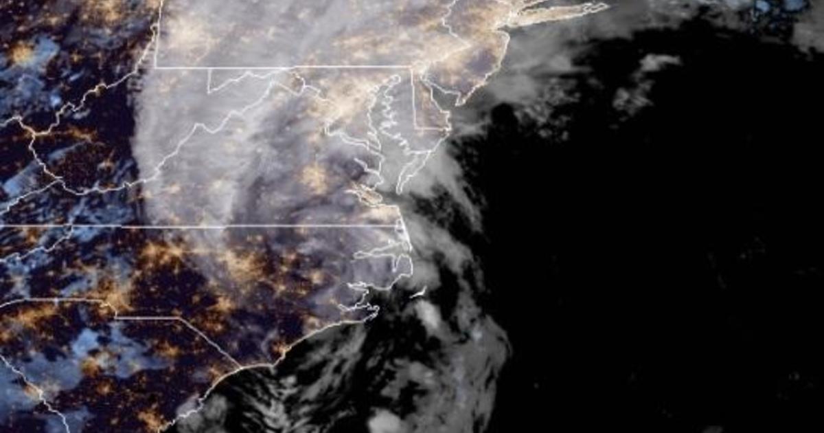
On-again off-again Hurricane Isaias made landfall late Monday night near Ocean Isle Beach, North Carolina, according to the National Hurricane Center. It touched down just after 11 p.m. with maximum sustained winds of 85 mph and immediately spawned several confirmed or possible tornadoes and caused fires and flooding.
Isaias (pronounced ees-ah-EE-ahs) had been upgraded again from a tropical storm to a Category 1 hurricane Monday evening. The storm’s maximum sustained winds dropped after it hit land to minimum-hurricane-speed of 75 mph with higher gusts. And by 3 a.m., it was back down to a tropical storm, with maximum sustained winds of 70 mph.
By then, Isaias was centered about 35 miles west/southwest of Greenville, North Carolina and 50 miles east-southeast of Raleigh, North Carolina. It was moving quickly north/northeast at 24 mph.
The center was forecast to move into southeastern Virginia around daybreak, hug the mid-Atlantic coastline today and continue across the northeastern U.S. tonight. Gradual weakening was expected.
The hurricane center warned of possible tornadoes in North Carolina early Tuesday, and from eastern Virginia to southern New England later Tuesday.
The National Weather Service Wakefield, Virginia office tweeted that a “radar-confirmed large and extremely dangerous tornado is on the ground and moving toward Downtown Suffolk, Va! If you live in/near Suffolk or know someone who does, take shelter immediately!
There were unconfirmed reports of other funnels in North Carolina and Virginia but no early reports of injuries or damage.
The storm unleashed flooding and sparked five home fires in Ocean Isle Beach, Debbie Smith, the town’s Mayor, told WECT-TV.
Firefighters from the town’s fire department were battling the blaze with assistance from Horry County firefighters in South Carolina, Tony Casey, a spokesperson for Horry County Fire Rescue, told The Associated Press.
At approximately 11:40 p.m., there were reports of multiple structure fires in the area of Ocean Isle Beach, North Carolina.
Horry County Fire Rescue is providing multiple units to help in response.#HCFR pic.twitter.com/L6cqjO6j9T
— Horry SC Fire Rescue (@hcfirerescue) August 4, 2020
About 80 miles north of Ocean Isle Beach, roughly 30 people were displaced due to a fire at a condominium complex in Surf City, news outlets reported. It’s not clear if the fires were connected to the storm. No injuries have been reported.
Duke Energy reported hundreds of thousands of power outages as heavy rains and winds battered areas including Wrightsville, Kure, and Carolina beaches in Wilmington, North Carolina.
Coastal shops and restaurants closed early, power began to flicker at oceanfront hotels and even the most adventurous of beachgoers abandoned the sand Monday night as newly re-strengthened Hurricane Isaias sped toward the Carolinas.
The hurricane center warned oceanside home dwellers to brace for storm surge up to 5 feet and up to 8 inches of rain in spots, as Isaias moved up the coast.
“All those rains could produce flash flooding across portions of the eastern Carolinas and mid-Atlantic, and even in the northeast U.S.,” said Daniel Brown, senior hurricane specialist at the U.S. National Hurricane Center. A tropical storm warning extended all the way up to Maine, where flash flooding was possible in some areas on Wednesday.
Isaias killed two people in the Caribbean and roughed up the Bahamas but remained at sea as it brushed past Florida over the weekend, providing some welcome relief to emergency managers who had to accommodate mask-wearing evacuees in storm shelters.
Authorities in Myrtle Beach, South Carolina, ordered swimmers out of the water to avoid rough surf and strong rip currents. By nightfall, power began to flicker at beachfront hotels as Isaias crossed the last bit of warm water on its path toward the U.S. mainland.
Still, on this part of the South Carolina and North Carolina coasts that has been affected to varying degrees by seven tropical storms or hurricanes since 2014, residents weren’t panicking.
Since forming last week, Isaias has been buffeted by competing forces both trying to kill and strengthen it, said University of Miami hurricane researcher Brian McNoldy.
“Of all the places it could be, it found the warmest water it could,” which fuels storm development, McNoldy said. “And yet it is struggling.”
That’s because dry air kept working its way into the storm at low and mid-levels, which chokes storms.
Isaias’ passage near Florida over the weekend was particularly unwelcome to authorities already dealing with surging coronavirus caseloads. The storm brought heavy rain and flooding to the state, forcing authorities to close outdoor virus testing sights, as well as beaches and parks. Officials tied signs to palm trees so they wouldn’t blow away.
About 150 people had to keep masks on while sheltering in Palm Beach County, which had a voluntary evacuation order for people living in homes that can’t withstand dangerous winds, said emergency management spokeswoman Lisa De La Rionda.
