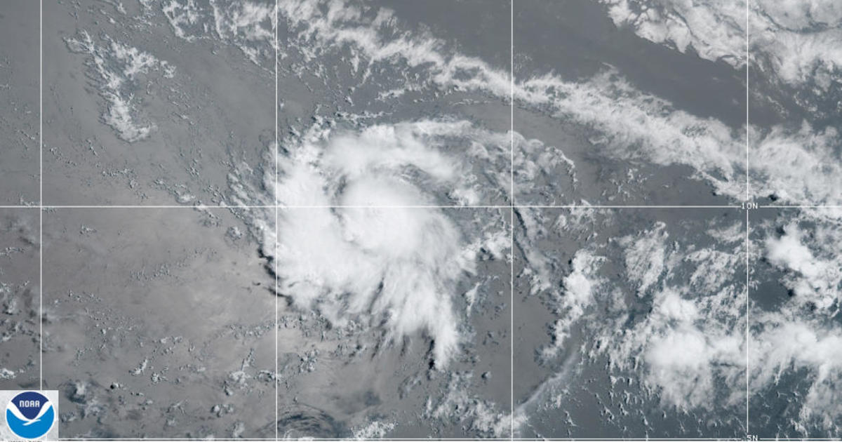
Tropical Storm Gonzalo formed on Wednesday in the central Atlantic Basin, about midway between the West African coast and the islands of the Lesser Antilles. At first it was expected to stay a tropical storm, but the National Hurricane Center has now revised its forecast to increase the chances it will become a hurricane Thursday night or Friday, before it approaches the southern Caribbean by the end of the week.
As of Thursday morning, the National Hurricane Center said a hurricane watch is in effect for the islands of Barbados, St. Vincent and the Grenadines. Gonzalo had maximum sustained winds of 65 mph and is moving to the west at about 14 mph. The storm is forecast to reach the southern Lesser Antilles by Saturday.
As I said yesterday, I had a feeling the global models were being a bit conservative with #Gonzalo. In fact the MSLP at 11a most reflects what the regional hurricane HMON/HWRF had forecast. (Those had a stronger storm)
Long story short, our first hurricane is possible this week. pic.twitter.com/aYf0wuSF6R
— Zach Covey (@ZachCoveyTV) July 22, 2020
While the future track of Gonzalo appears fairly straightforward, the intensity is very uncertain. The computer models meteorologists use to forecast these systems are split into two camps. The global computer models, like the well-known European model, show the system weakening as it reaches the Lesser Antilles and Caribbean. But specialized tropical models are more robust, showing the storm strengthening to a hurricane and remaining that way through the next 5 days.
Tropical Storm #Gonzalo is looking healthy this morning. The latest @NHC_Atlantic guidance makes it the first hurricane of the Atlantic season by tomorrow. Intensity forecast uncertain -Models diverge in 48 hours – Global models forecasting weakening & tropical models stronger. pic.twitter.com/qzrCfzlIPT
— Jeff Berardelli (@WeatherProf) July 22, 2020
There is no telling which group of models will prove correct, but so far the tropical models seem to be doing a better job. That is partly because Gonzalo is a small system and these tropical models are able to better analyze smaller-scale features.
Often small systems can shield themselves from the surrounding environment. In this case there is dry air around the system. The stronger tropical models keep the influence of dry air to a minimum by cocooning, or protecting, the storm, allowing it to strengthen. The larger-scale models allow the dry air to feed in, weakening the storm’s structure and thunderstorms.
The latest microwave pass over Tropical Storm #Gonzalo is revealing. Curved bands do indicate a well organized vortex. Inner core convection is trying to close off but battling drier air imported from the E via light NE shear.
For now this drier air source is still fairly moist. pic.twitter.com/j8eMcEzndS
— Philippe Papin (@pppapin) July 22, 2020
Regardless of what happens next, Gonzalo is already one for the record books. It is the earliest 7th named system of any Atlantic season on record.
#Gonzalo has formed in the central tropical Atlantic – the earliest 7th Atlantic named storm formation on record. The prior record was Gert on July 24, 2005. #hurricane pic.twitter.com/y6juycGbi6
— Philip Klotzbach (@philklotzbach) July 22, 2020
And by the end of the week there may be another named system, this time much closer to home. The National Hurricane Center is monitoring a broad area of low pressure with a disorganized cluster of storms over the central Gulf of Mexico. The chance of development has now increased to 80%, with a tropical depression or tropical storm is likely to form by Friday. Either way it will likely bring gusty winds and heavy downpours into Texas by Friday and Saturday.
The Gulf of Mexico Invest #91L is starting to fire off some vigorous convection this morning. The disturbance is making an attempt to develop into a tropical cyclone.
This disturbance has its crosshairs on the Texas coast. pic.twitter.com/wcpcirK1Mp
— Mike Ventrice (@MJVentrice) July 22, 2020
One reason for the active season so far has been unusually warm waters in the tropical Atlantic, and that seems to be continuing. Gonzalo marks the beginning of the second phase of hurricane season, which is called the Cape Verde season. This is when systems in the main development region, in between Africa and the Caribbean, flare up. It usually occurs in early to mid August, but this season it is starting several weeks early. This is partly due to near historic warm sea surface temperatures in the main development region.
Not to beat a dead horse but, the Atlantic Main Development Region is exceptionally warm atm. Here's a plot of the OISSTv2.1 SSTa percentiles for the week ending July 20th.
Grid points that exceed the 95th percentile (within the top 3 ranks) are contoured in white#Tropics
🔥🔥 pic.twitter.com/p8n2sG2TeJ— Eric Webb (@webberweather) July 22, 2020
Also, Gonzalo is forming very far south compared with most other tropical systems.
There have been a few south of 10ºN, but it's sparse.
Here's how the forecast track of #Gonzalo compares to the full climatology. pic.twitter.com/G444foFSM3— Sam Lillo (@splillo) July 22, 2020
Its prospects beyond the weekend are very uncertain right now. But there is at least some chance it will remain a hurricane in the Caribbean and if so, this storm will need to be watched closely to see if it makes the turn north towards the U.S. or moves west into Central America.
After Gonzalo, computer models are showing another system with a good potential for development now emerging off of Africa. While its fate is uncertain, what does seem certain is that an active couple of weeks — and likely hurricane season as a whole — is now upon us. This is in line with all of the seasonal forecasts from various organizations warning it’s likely to be one of the most active hurricane seasons on record in the Atlantic.
