Managua, Nicaragua — Dangerous and powerful Hurricane Eta churned toward Nicaragua’s Caribbean coast with potentially devastating winds early Tuesday while heavy rains from its outer bands were already causing rivers to overflow across Central America. The Category 4 hurricane had sustained winds of 145 mph, down slightly from 150 mph at their peak.
The U.S. National Hurricane Center, in Miami, said “extremely dangerous” Eta was “very near” the northeastern Nicaraguan coast. It said “life-threatening storm surge, catastrophic winds, flash flooding and landslides are expected across portions of Central America.”
At 7 a.m. EST, Eta was centered about 30 miles southeast of Puerto Cabezas, Nicaragua, and moving west-southwest at 4 mph. Hurricane-force winds were already hitting land.
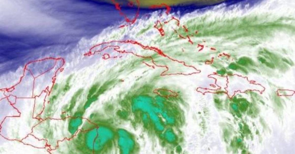
Hurricane Eta just about over Nicaragua early on November 3, 2020. The southern half of Florida can be seen at the top center.
National Hurricane Center
The center said little change in Eta’s strength was expected before Eta made landfall, likely later in the morning, adding that Eta would then start to lose some power as it moved inland later in the day.
CBS News meteorologist and climate specialist Jeff Berardelli noted that when Eta had 150 mph winds, it was the strongest hurricane of the season. Laura also had 150 mph winds but its barometric pressure wasn’t as low.
Authorities in Nicaragua and Honduras moved people from outer islands and low-lying areas to shelters. Residents scrambled to shore up their homes, but few structures along Nicaragua’s remote Caribbean coast were built to withstand such force.
Nicaragua’s army moved red-helmeted troops specialized in search and rescue to Bilwi, the main coastal city in an otherwise remote and sparsely populated area. The navy spent Monday ferrying residents of coastal islands to shelters in Bilwi, also known as Puerto Cabezas.
The government said more than 3,000 families were taken to shelters from the most at risk areas.
Evacuees are seen at a sports center being used as a shelter as Hurricane Eta approached Tela, Honduras, on November 2, 2020.
JORGE CABRERA / REUTERS
At a shelter in Bilwi, farmer Pedro Down waited late Monday for Eta’s arrival. “When it comes it can rip off all the (roof) and destroy the house, so you have to look for a safer place,” he said, cradling a baby in his arms. “So I came here to save our lives.”
On television Monday, Nicaragua Vice President and first lady Rosario Murillo prayed for God to protect the country. She said Nicaragua would apply lessons learned from previous storms. “How many hurricanes have come and we have moved on, thanks to God,” she said.
Along Honduras’ northern Caribbean coast, torrential rains from Eta’s outer bands caused some rivers to overwhelm their banks Monday, forcing evacuations.
In Honduras, Q’hubo TV reported that 12 people, including two newborns, were trapped in the community of San Luis in Olanchito, Yoro.
The entire region was experiencing what could be only the beginning of Eta’s destruction. The storm was forecast to spend the week meandering over Central America dumping rain measured in feet, not inches.
Forecasters said central and northern Nicaragua into much of Honduras could get 15 to 25 inches of rain, with 35 inches in isolated areas. Heavy rains also were likely in eastern Guatemala, southern Belize and Jamaica.
A storm surge up to 15 feet above normal tides was possible for the coast of Nicaragua, forecasters said.
The quantities of forecast rain were already prompting comparisons to 1998’s Hurricane Mitch, one of the most deadly Atlantic hurricanes in history. An archival report from the National Hurricane Center said Mitch led to the deaths of more than 9,000 people.
Eta tripled in strength in about 24 hours, rapidly intensifying from a 40 mph storm Sunday morning to a 120 mph hurricane around midday Monday, and continuing to gain power throughout the day.
It’s the eighth Atlantic storm this season to hit the meteorologists’ definition for rapid intensification – a gain of 35 mph in wind speed in just 24 hours. It’s also the fifth to reach major hurricane status.
Over the past couple of decades, meteorologists have been increasingly worried about storms that just blow up in strength.
Eta is the 28th named Atlantic storm this season, tying the 2005 record for named storms. It’s the first time the Greek letter Eta has been used as a storm name because after the 2005 season ended, meteorologists went back and determined a storm that should have been named wasn’t.
Hurricane season still has a month to go, ending Nov. 30. In 2005, Zeta formed toward the end of December.
